
tour lac saint helene

papou73
User
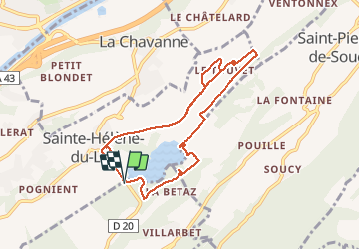

Length
9.6 km

Max alt
334 m

Uphill gradient
170 m
Km-Effort
11.9 km

Min alt
255 m

Downhill gradient
171 m
Boucle
Yes
Creation date :
2019-12-10 08:07:55.974
Updated on :
2019-12-10 10:53:29.353
2h44
Difficulty : Very easy

FREE GPS app for hiking
 SityTrail
IGN / Geographical institutes
SityTrail Plus
The world is yours!
About
Trail Walking of 9.6 km to be discovered at Auvergne-Rhône-Alpes, Savoy, Les Mollettes. This trail is proposed by papou73.
Photos


Positioning
Country:
France
Region :
Auvergne-Rhône-Alpes
Department/Province :
Savoy
Municipality :
Les Mollettes
Location:
Unknown
Start:(Dec)
Start:(UTM)
270969 ; 5040212 (32T) N.
Comments